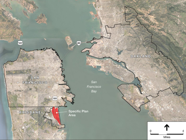
Last week, the City of Brisbane’s proposal for the Baylands development area was opened for public review through the CEQA application page. The specific site plan, developed in partnership with the Metis Environmental Group and Environmental Science Associates, is a sweeping redevelopment of more than 680 acres along Highway 101 and the Caltrain tracks between San Francisco and South San Francisco.
The plan details new zoning areas and transportation routes for the mostly unoccupied area. Current developments include a maintenance yard, industrial park, and nursery. The new site plan will include 2,200 residential units, 6.5 million square feet of commercial, office, or retail space, including possible life sciences and conference developments, 500,000 square feet of hotel usage, a new 6-8 middle school campus, and 157 acres of open space including parks, trails, and other usage.
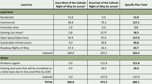
Brisbane Baylands Land Use Acreage Chart, image via Brisbane Planning
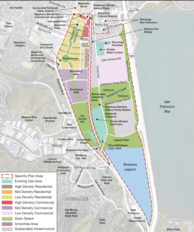
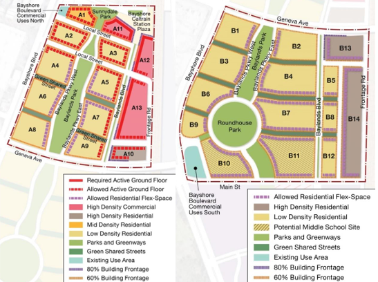
Brisbane Baylands Site Plan Zoning Map, image via Brisbane Planning
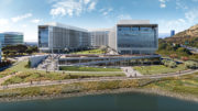
Building heights within the development area would vary from a 50-foot maximum in the low-density residential areas up to a 270-foot maximum for high-density residential and office areas. The majority of high-density buildings are to be clustered around the Caltrain station, creating walkable and commutable options. With several parcels proposed to be above 200 feet, the site plan depicts loose blocking of a potential Brisbane skyline.
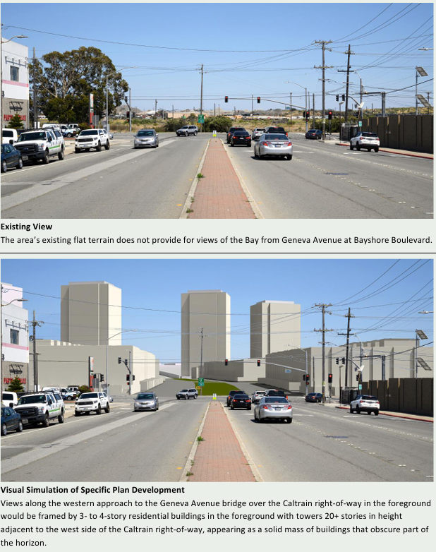
Brisbane Baylands Buildings Blocking from Geneva Avenue, image va Brisbane Planning
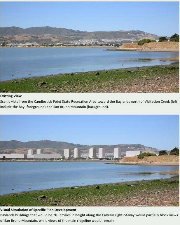
Brisbane Baylands Buildings Blocking from Candlestick Point, image via Brisbane Planning
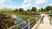
The main residential zoning area runs along the northwestern portion of the site, bordered by the Caltrain tracks and Bayshore Boulevard, and bisected by the extension of Geneva Avenue. Called Bayshore Village, the area is designed with a central green area running through it, creating a green and walkable neighborhood atmosphere.
A more modest area of open land, referred to by the plan as Baylands North, lies just outside the development area, within the City and County of San Francisco. While plans for this area are not included in Brisbane’s Specific site plan, future developments in that area are likely to benefit from the increased transportation and commercial resources.
Brisbane Baylands Village Plan, image via Brisbane Planning
The specific site plan also calls for the implementation of several different transportation strategies. The park design is specifically planned to maximize walkability, and new bike lanes will be threaded throughout the new streets. However, mass transit will center on the upgrading of the current Caltrain station and the construction of a new BRT line along Geneva Ave. The current Brisbane Caltrain station will be converted into a multimodal transit facility, connecting to the BRT and additional local shuttle lines.
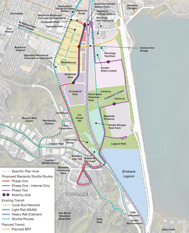
Brisban Baylands Transportation Map, image via Brisbane Planning
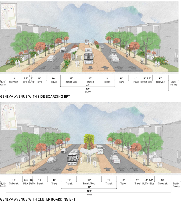
Brisbane Baylands Geneva Ave BRT Proposed Plan, image via Brisbane Baylands
The site plane also makes provision for a new light maintenance facility for the future California High Speed Rail extension. The facility will provide employment and a place to service the trains that will run between San Francisco and Los Angles. While the HSR will not stop at the station in Brisbane, residents will have Caltrain transfer options in San Francisco and Millbrae.
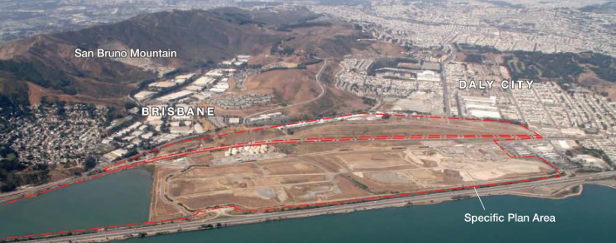
Brisbane Baylands Current Site Aerial View, image via Brisbane Planning
Subscribe to YIMBY’s daily e-mail
Follow YIMBYgram for real-time photo updates
Like YIMBY on Facebook
Follow YIMBY’s Twitter for the latest in YIMBYnews
This project has been in the planning phase since I was in my twenties, and that is a long time ago.
Although it’s low on housing units I like the density at least near the station, however on the map I didn’t see a spot for a high speed rail yard, which I believe the old southern pacific yard was the ideal location for? Hopefully they can manage to start construction on this area soon, but given how long they’ve taken already, it’ll be over a decade until shovels get in the ground.
Put the development into downtown SF. Reduce the scale along the bay.
A very HAPPY & BLESSED EASTER to you, Eric!🐣😊🐰🐥🐇🐤🙏🏻
To build only 2200 homes on 650 acres suggests the Bay Area is only giving lip service to our housing crunch. With SO much commercial nearby do we really need what is proposed? (No)
As YIMBY, I love it. However, I forsee the NIMBYs in Brisbane will never allow it.