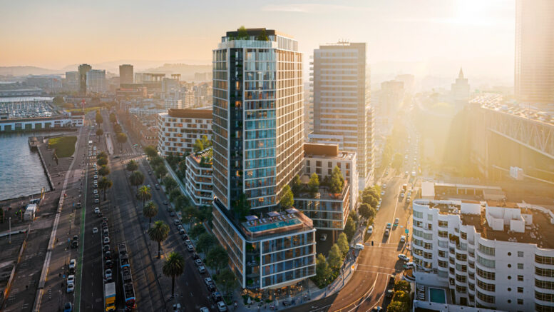
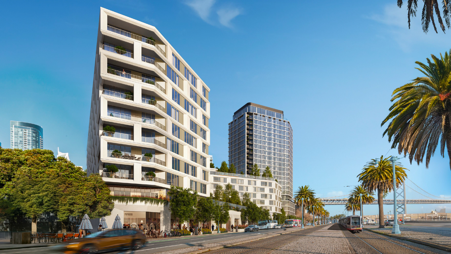
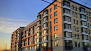
Updated renderings have been published for Strada’s waterfront housing development at 555 Beale Street, San Francisco. The new illustrations showcase the design by the international architecture studio Grimshaw for two residential buildings expected to deliver over six hundred units along The Embarcadero. Construction could start as early as next year.
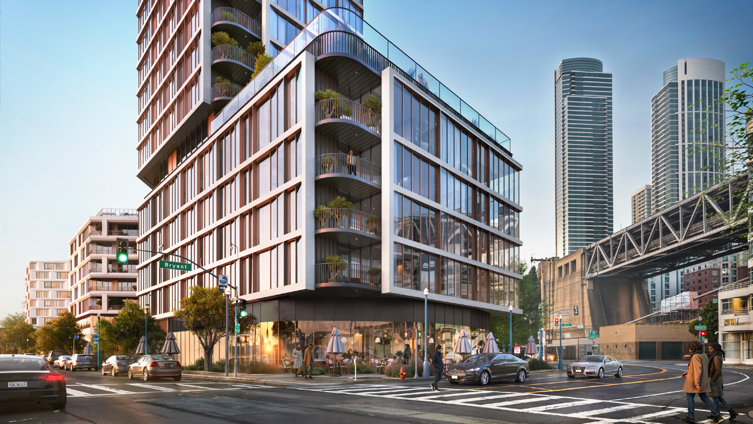
555 Beale Street Building 1 podium view, design by Grimshaw and Perry Architects
555 Beale Street updated design massing, design by Grimshaw and Perry Architects
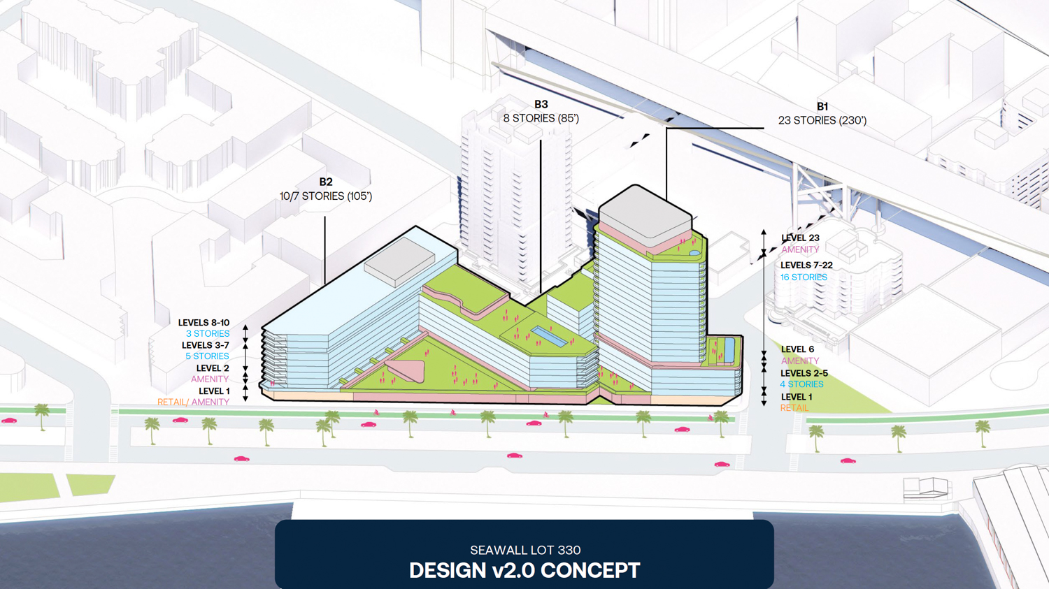
London-based Grimshaw Architects is leading the design for 555 Beale Street, working in partnership with San Francisco-based Perry Architects. The proposed 23-story tower is not quite tall enough to noticeably alter the waterfront skyline surrounding the Bay Bridge. The highest point of the masterplan would rise only as tall as its neighbor. To further reduce the visual impact of the development, the project team states that “massing is sculpted to preserve view corridors,” adding that “90% of site coverage is below 105 feet.”
Full build-out will yield around 600,580 square feet across the two structures, with 433,460 square feet of housing, 186,290 square feet for parking, and 6,970 square feet of ground-level retail. Unit sizes will vary, with 162 studios, 321 one-bedrooms, and 136 two-bedrooms. The podium-level garage will be provided for 354 cars and 37 bicycles. Of the 619 apartments, 93 will be deed-restricted as affordable housing.
There is a third parcel, dubbed Building 3, which is expected to become fully-affordable housing under a separate application.
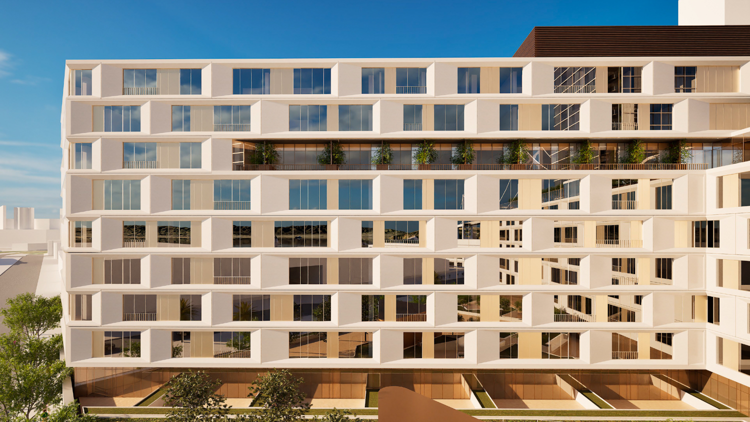
555 Beale Street Building 2 aerial overview, design by Grimshaw and Perry Architects
555 Beale Street Building 2 pedestrian view, design by Grimshaw and Perry Architects
The plans for housing at 555 Beale Street, also addressed as Seawall Lot 330, were previously dependent on the commercial redevelopment of Piers 30-32, all on city-owned property. Last July, Strada Investment Group received approval from the city’s port commission to alter the development agreement and separate the office and housing projects.
The Executive Director of the Port of San Francisco, Elaine Forbes, said that the developer has determined that based on “based on a $125 million infrastructure funding gap, the complex timing of the U.S. Army Corps-led seawall project, prolonged weakness in the office market, and uncertainty in federal infrastructure funding,” the office component for Piers 30 and 32 is too speculative to proceed.
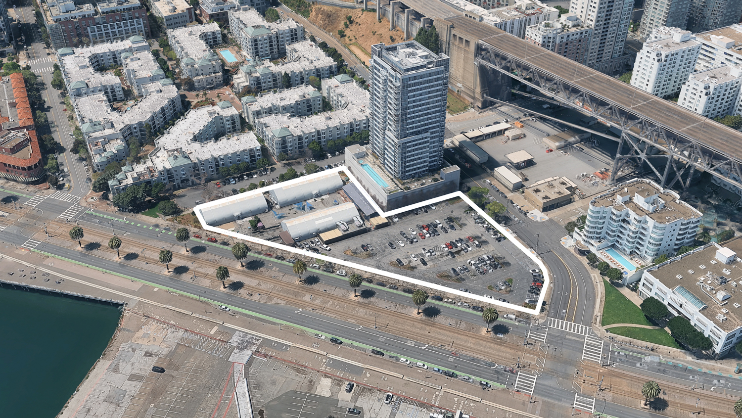
Seawall Lot 330, image via Google Satellite outlined approximately by YIMBY
The 2.3-acre property is located along Beale Street and the Embarcadero, directly across from Piers 30 and 32. The site is currently occupied by surface parking and a non-profit-led navigation center. Construction is estimated to cost at least $600 million, with work expected to start as early as next year.
Subscribe to YIMBY’s daily e-mail
![]()
Follow YIMBYgram for real-time photo updates
Like YIMBY on Facebook
Follow YIMBY’s Twitter for the latest in YIMBYnews
If the office environment is challenging, why not just build more housing there?
Cool idea for sure, but there’s no way you’d recoup costs given all the expensive pier work that needs to happen first.
The original proposal had office space only on the pier, not on SWL 330. As the article states and as Bobby notes in their comment, completely rebuilding the piers and the related Embarcadero waterfront is more expensive than can be justified or paid for by a small amount of (admittedly very desirable) office space in a city with a 30%+ office vacancy rate.
Plus my understanding is that the rules that created the SF Port Commission do not permit residential uses (including hotels) on the piers. Only maritime-related office and commercial uses. I can’t point to a specific law/rule/requirement but that has been my understanding.
Wonder if the residents of the tower next door, who put up a massive fight about the homeless shelter at the parking lot, will prefer the homeless shelter to three years of construction followed by their views being taken away / impacted?
The design looks consistent with and actually toned down from what was always known to be planned for the remainder of SWL 330. Over the past 20 years I’ve seen various proposals for two tall towers at each end and a lower section in between. Now there’s only one tall tower that looks like it’s designed to minimize the impact on views. The lower building might block only the bottom 3-5 residential floors of the Watermark.
I am disappointed this will only be 619 units – I feel like the original proposal from Strada was for close to 1,000 units?
Looks great BTW, as a neighbor so glad to see something going in there finally.
It’s too bad they didn’t try to go bigger and bolder for this site. Such a prominent location along the city’s waterfront would be prime for a 73 floor supertall and would make for a fine bookend to the Bay Bridge as a grand entrance into the city.
Something like Victoria Dockside (Hong Kong) would’ve be mega
You can’t it’s land fill and water underneath , if you go higher the building would sink.
I hear you, but I think engineers would be able to help with that.
Im quite happy with the design they went with. I think adding as much housing as possible without creating a “sea wall” is desirable.
100%
I’m not sure a single building would constitute a “wall”. Remember, this is the last developable site along the waterfront. I agree that we should add as much housing as possible, which is why we should maximize this site’s potential. It will probably be at least another 60-70 years before the nearby apartments get old enough for redevelopment, which is why we should build with that time frame in mind.
‘Remember, this is the last developable site along the waterfront.”
Yes, for the southern waterfront from the Ferry Building down to Mission Bay. But lets not forget there’s still several large triangular parcels on the northern waterfront: 1) the cursed Bay Club Tennis and swim facility on Drumm between Washington and Broadway; 2) surface parking on Davis between Broadway and Vallejo; 3) surface lot on Front between green and Union; and 4) on Kearny between Bay and Northpoint. Each of those could be a spectacular residential location in the right hands.
In addition, I’ve love to see the low-slung buildings in the blocks behind the parking lots such as the ABC 7 building developed. And it seems to me the one-story sewage treatment plant between Bay and North Point could have a 6-8 stories of residential on top of it even if you leave the treatment plant there.
Built it!
A solid design by Strada and Grimshaw. Will be a nice addition to the City and the waterfront
Nice scaling and design. But so much parking. Oh, well. Nice addition.
Agree the scaling and design looks great. I don’t think parking for 50% of the units is a lot for what will be expensive housing. I assume your (unstated) concerns are the impact on traffic along with pollution/global warming. Many/most people won’t use their cars daily. We live in a building two blocks away with parking for about 80% of the units. My husband and I both walk to and from work in the FiDi and used Muni. Most of my neighbors don’t drive their cars every day either. We have a car (electric, like many in our building) and use it for occasional shopping runs/weekend outings. Maybe once/twice a week.
Cars aren’t the problem; driving them a lot is.
Building 1 is gorgeous, love the floor to ceiling windows. Building 2 is disappointing in comparison – looks like Serif on Market 🙁
That area is intensely bleak, especially at night.
Where’s the Safeway, the UPS Store, Walgreens etc?
I think the area does need a grocery store, shipping stores, pharmacies, barber shops, nail salons, and the like, especially as it continues to densify. It’s quite a far walk to the nearest Safeway at 4th & King. That being said, at 20-30k ppsm it’s still relatively low density on par with neighborhoods like the Marina, Pacific Heights, Outer Richmond, and the Outer Sunset. It will need to rely on continued high density projects like this one to bring in more traffic to support such small businesses.
600k sq feet for 600+ units, but they could only find space for 37 bikes?
I thought that too, but maybe they assume people will take their bikes up to their units? It’s not clear whether they plan for the units to be condo/ownership or rental apartments – the description uses the word “housing” in most of the article but does use the word “apartment” once. Usually an ownership/condo building prohibits people from bringing their bikes up the elevator because they’ll ding up the walls and get the hallway carpets dirty – we live two blocks away and our (condo) building prohibits bikes in the elevators. But our three good-sized bike rooms are jam-packed and they actually took some of the garage/parking space and made it more bicycle racks.