San Francisco Planning Commission is scheduled to review plans to increase the residential capacity of the Stonestown Galleria master plan. The new plan will create nearly 3,500 residences and reduce non-retail sales and service spaces. To add more housing, the plans for a hotel have been removed. Brookfield Properties is the developer, and the meeting is scheduled for this Thursday.
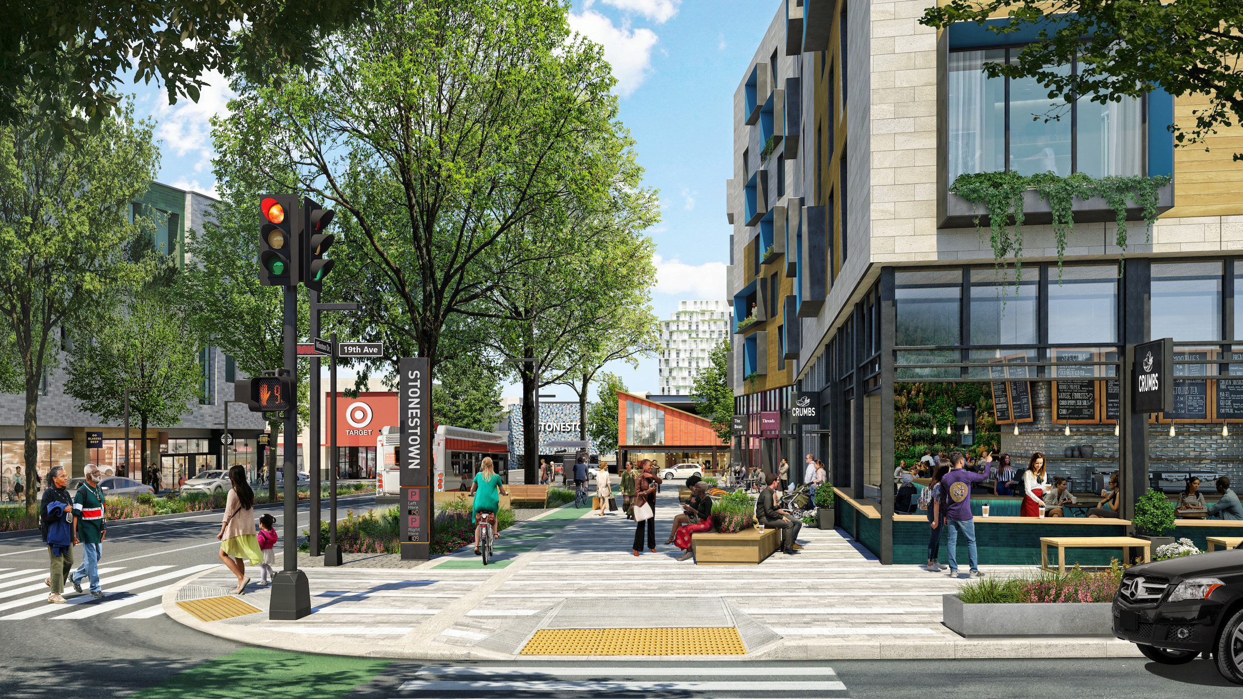
Stonestown 20th Avenue pedestrian walkway, rendering courtesy Brookfield Properties
The project has received significant support from the Sierra Club. Charles Whitfield, chair of the San Francisco Group Sierra Club, wrote to Mayor London Breed, “I am writing on behalf of the over 6,000 members of the Sierra Club in San Francisco to express support for the proposed development at Stonestown Galleria. This project would see Stonestown evolve from a mall with 27 acres of parking lots to a vibrant, mixed-use community with nearly 3,000 new homes.”
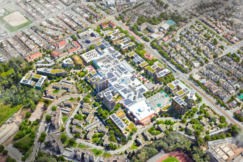
Initial plans for Stonestown would create 2,930 homes, 935,000 square feet of retail and medical facilities, 200,000 square feet of office space, a 200-key hotel, and parking for 3,960 cars and 1,187 bicycles. To increase the residential capacity by 411 units, the hotel at Block E3 will be replaced with a 96-unit apartment complex. Retail space will be reduced by 104,000 square feet to create around 190 units. The remaining 125 units may be created by converting Block S3 into a fifth tower.
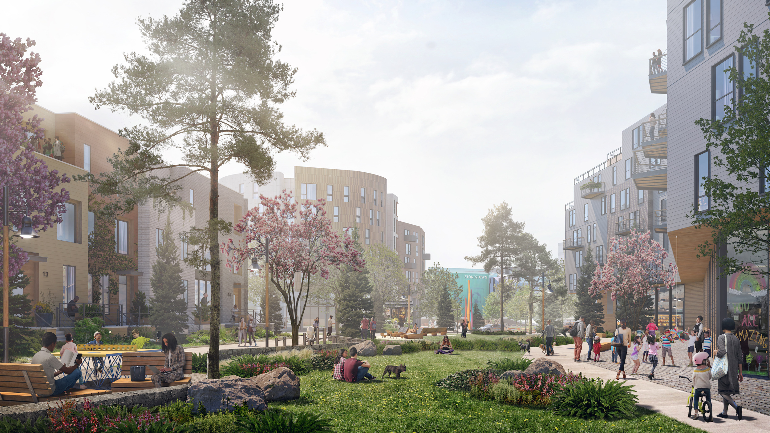
Stonestown greenway, rendering courtesy Brookfield Properties
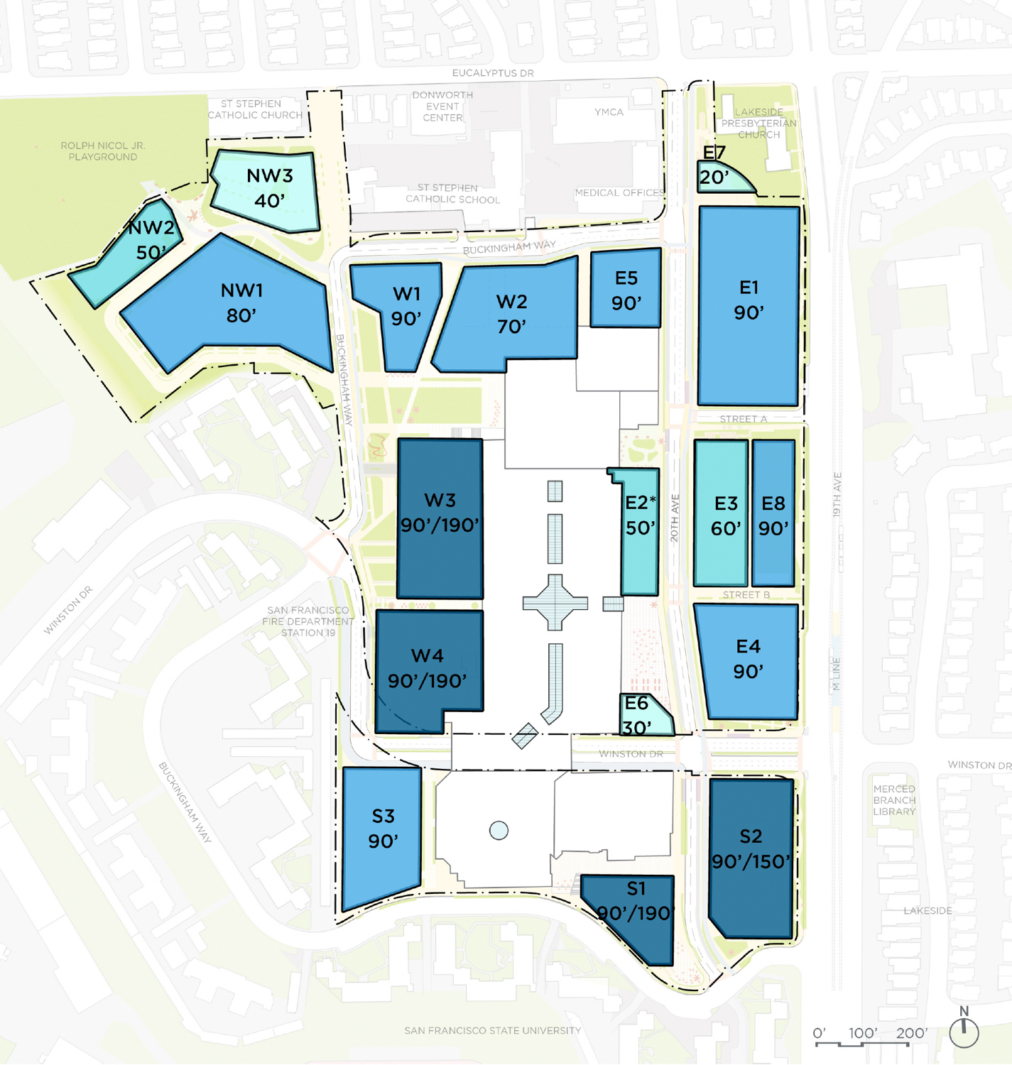
Stonestown Development proposed height plan with Authentic Church property included (E8), illustration courtesy Brookfield
The updated project now aims to have 3,491 apartments, 160,000 square feet of retail, 63,000 square feet of institutional space, 96,000 square feet of office space, and parking for 4,861 cars and 1,277 bicycles. Around six acres of privately owned public open space will be created around the existing Stonestown mall, which will remain mostly unchanged during construction. The apartment sizes will vary, with Brookfield estimating that of the 3,491 units, 19% will be studios, 38% will be one-bedrooms, 28% will be two-bedrooms, 9% will be three-bedrooms, and 6% for senior units.
The development has not yet established what ratio of affordable housing will be included, but a brief document, Brookfield writes that Stonestown will “provide hundreds of units of affordable housing at a higher percentage than required for a project meeting existing Planning Code requirements. These affordable units will include components set aside for seniors and educators.”
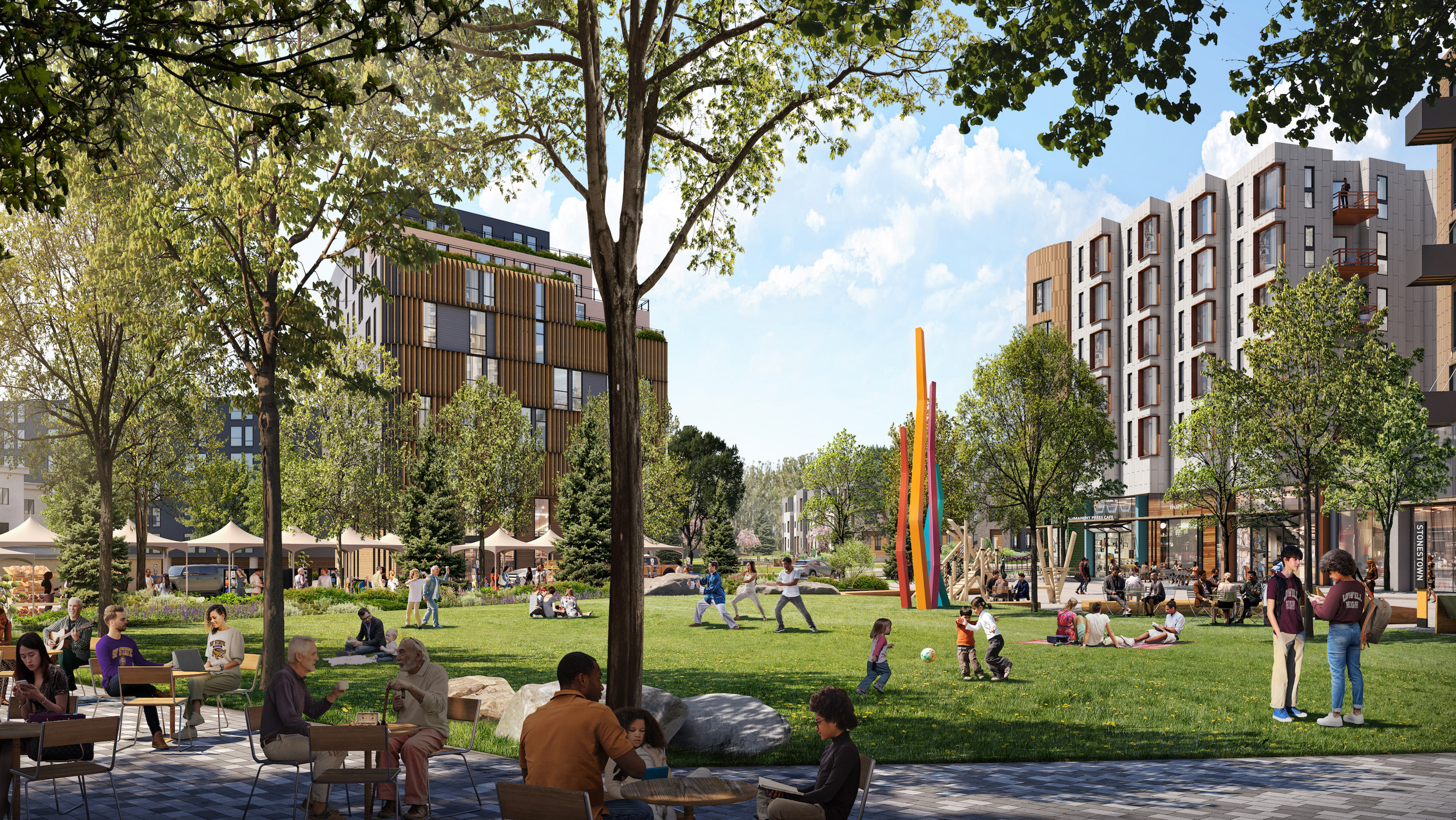
Stonestown town square, rendering courtesy Brookfield Properties
Stonestown Winston Gateway, rendering courtesy Brookfield Properties
The 43-acre parcel is currently occupied by the 11-acre mall, three acres of street, and 27 acres of surface parking. Construction will focus on rebuilding the 27 acres of surface parking and an adjacent three-acre parcel.
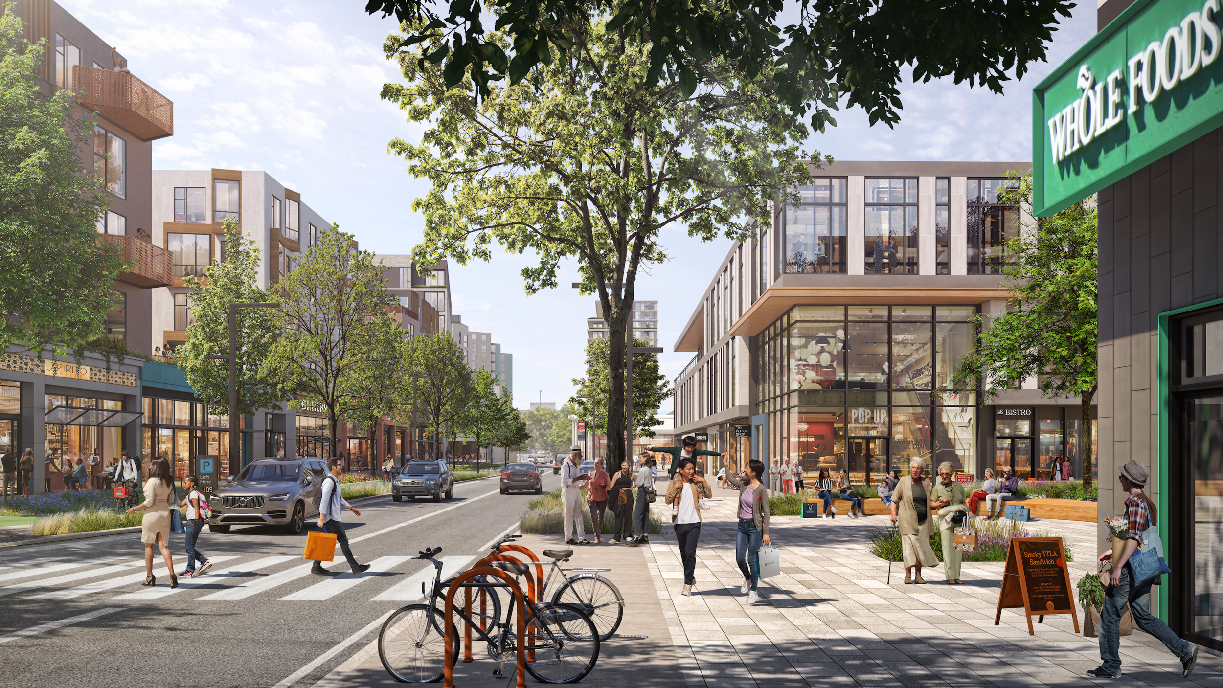
The project team includes SiteLab Urban Studio, Einwillerkuehl Landscape Architect, David Baker Architects, Fehr & Peers, and CBG. Other contributions have been made by Atelier Ten, Walter P Moore, BCV Architecture and Interiors, and CallisonRTKL. These initial renderings show a broad idea of how future buildings may look, though specific details about each building have yet to shared.
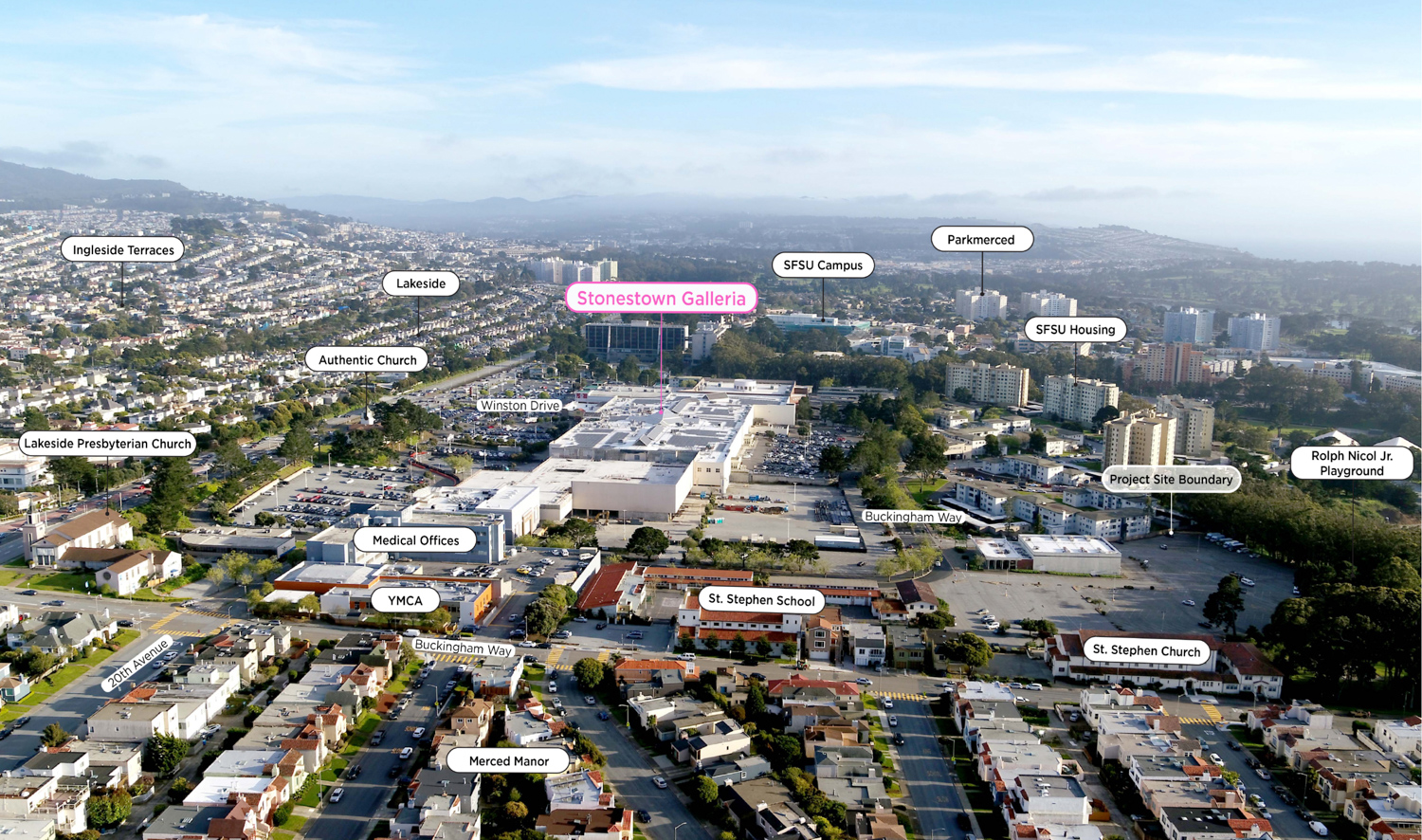
Stonestown Galleria surrounding context, image via Planning Document
The public meeting is scheduled for Thursday, September 14th, starting at 1 PM. The event will occur in person and online. For more information about how to attend and participate, visit the city website here. The Brookfield presentation will be informational and is scheduled as the second-to-last item in the meeting.
Construction is expected to last around 15 years, with the estimated groundbreaking date yet to be established. The development is expected to cost over $2.4 billion.
Subscribe to YIMBY’s daily e-mail
![]()
Follow YIMBYgram for real-time photo updates
Like YIMBY on Facebook
Follow YIMBY’s Twitter for the latest in YIMBYnews
Why are the buildings so short? They are building projects like this in Mountain View and Sunnyvale. It’s sad that they are limiting themselves to this height in a supposedly “world-class” city. Sad.
Considering there is no high-capacity subway (light rail is constrained capacity at the moment) close to here beyond a 20-30 min muni ride, I think it’d be problematic to suddenly add 20,000 people living in high rises to this site without an efficient way for them to get around. Note the thousands of parking spots (4k+) for a rather mid-rise neighborhood. It’d be traffic-inducing to add all these cars to the already congested road so I think if we were to upzone and allow for higher heights (which I think is a good idea), it should be coupled with an actual plan for improved transit capacity in 10-15 years. The M-line subway was scrapped and the Geary/19th ave is likely a few decades away still. Brookfields is already dreaming big, but if the city really wants to invest, we should coordinate at a long term scale.
If the plan is to open these units in 5-10 years, then we pretty need to break ground on an subway construction, like now.
There’s always an excuse. The renderings of this project look like they belong to any B-tier city in America. In NYC they build grand monuments without excuse or apology. Sure they have better subway/transportation but this city is supposed to “transit first”, meaning we shouldn’t account for car traffic when considering these projects.
“High Capacity Subway” is not a valid excuse. BART, Caltrain, Muni, etc. are all still used at levels 60%+ below 2019.
So that excuse does not fly at all.
Give me a break. There is nothing significantly wrong with this plan and it’s well executed and well thought out. You have no clue about world class cities if you think everything has to be over 10 stories everywhere to be ‘world class’. SF has a central area like other world class cities. And most world class cities, heard of Paris?, have there main housing type in the central quadrants all around 5-6 stories. We were just there on vacation and got to stay in one of the apartments on the 5th floor, beuatiful, within a vibrant active street life. This can’t be Paris in terms of history but the density and mixe of stores and shops is an admirable attempt to reimagine a major shopping mall.
Some of the apartment buildings appear to be 6-story, so that is not bad.
If the whole thing was 4-storys or less, that would be suboptimal. But some parts of this project are 6-story.
Some are planned to be 18 stories.
Even better, if true. That is not in the pictures. Only in text in the SF Chronicle article.
Actually if you lol Kathy he approved heights you’ll see up to 190’
I love this. Agreed with the above comments about mid-rise density working well in comparison with Europe. Where mid-rises fail in suburban settings is when they’re interspersed with excessive single-use commercial and surface parking, as in most “town center” projects.
a) why no inclusion of the petco, the YMCA and YMCA Annex? Both sites should be part of the redevelopment. Toss in the pumpking patches down on sloat and at 19th and you could have some mixed use density along sloat next. Also add in the churches, since Wiener did propose new density on church land.
b) M-Line has gone nowhere, L-Taraval also could run up sloat turn at 19th and run through the site, using the ramp to 19th? SFMTA should be more up front and forward on their projects and proposals (shovel ready) without serious transit changes, on the west side, carmeggedeon will occur when the construction of multiple sites starts and everyone drives and delivers to these areas… Already bad, but expect worse and backups far beyond daly city… (Hyperloop down to san jose?
c) All for more density at stonestown, problem is the layout protecting the mall (in decline) vs. opening it up and using the east side for a denser array along with a transit link… We had a design across from Mercy HS station stop above grade, housing on 19th and sinking the roadway of 19th underground… would make a much better urban plan and direct plaza at the Whole foods and medical building. with parking underneath… with new office towers north and south. Density can help, but it can hinder, when the transit and infrastructure lags so far behind in the west side….
If this were a world-class city, this type of development would be PRECEDED by improvements in transit…more frequent, more lines, longer-car light-rail, etc.
Look at the crappy Van Ness “bus lane”…used by 2, count ’em, lines, 15+ minutes headway, and NO signal priority! SF MTA planning and execution is a joke. Perhaps only marginally better than BART
Van Ness BRT has signal priority at its northern end (Filbert Street), for northbound buses, and also for left-turning, southbound Golden Gate Transit buses at Golden Gate. It serves three Golden Gate Transit lines and two Muni lines. Pre-pandemic there were two additional Muni lines and also additional Golden Gate Transit lines on Van Ness.
It’s been a huge success for bus riders, massively speeding up travel time and reliability. What used to feel like a long, slow street to travel on by public bus is now fast and short. Current Muni daytime frequencies are officially every six minutes and, from my experience, one rarely waits more than eight minutes for a Muni bus.
Just read: 4861 parking spaces? Methought SF is trying to discourage cars?
I concur – far too many parking spaces, especially in an ostensibly transit first city.
Living in this area, I am once again shaking my head at the logic of the city. The Sunset has been overlooked time and time again. We have no infrastructure out here!! Why would they allow so many new housing units without first bolstering the basically non-existent public transit? It is an embarrassment that we have to tellpeopl not to bother taking public transit to our home. In fact, the bus that runs along Sloat we call the, “Elusive” bus. I can’t even tell you how many times trying to get from SLOAT AND 19th AVE., notably one of the busiest thoroughfares in San Francisco, I have had to run back and fourth between Ocean and Sloat and up to the M Line trying to get on any one of them going south.
We don’t even have a viable water source for fires out here. It’s absolutely unconscionable that development is allowed without solving these problems. As people are exiting San Francisco in record numbers, I think I more and more housing in order togetfunding from the state needs to be re-evaluated.
Do any of y’all actually grow up here or you’re just talking while being transplants